
We research, care for and share the archives of the parish of Barton Stacey, Hampshire.


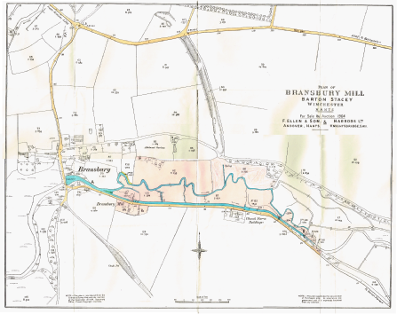
The Andyke, Bransbury
Extract from https://historicengland.org.uk/listing/the-list/list-entry/1015678
This monument is scheduled under the Ancient Monuments and Archaeological Areas Act 1979. Date first scheduled: 30 Nov 1925.
The earthwork, which is refered to as `Auntediche' in an Anglo-Saxon charter, has previously been interpreted as the defences of an Iron Age promontory fort. Current understanding of the monument does not allow this interpretation to be verified and the scheduling is consequently restricted to the earthwork itself.
Above left:
1910 Ordnance Map. The A303 road separates the northernmost section of the Andyke from the rest, which runs southward as far as Crook and Shears Lane, Bransbury. (This is part of the 1964 sale documents of Bransbury Mill, which happens to show the Andyke particularly well).
The line of the earthwork has been breached by the A303 which, at its point of intersection with the Andyke, is in a cutting sufficiently deep to have removed all archaeological deposits. The monument is consequently divided into two areas of protection, separated by the A303 cutting.
Although current understanding of the Andyke is incomplete, the earthworks will contain information relating to their construction and to the environment and economy of their period of use. In addition, the earthworks form a highly visible element of the historic landscape.
The monument, which falls into two areas, includes the Andyke, a substantial earthwork over 530m in overall length, which cuts off a low peninsula between the valleys of the River Test on the north and the River Dever (the Wonston Stream) to the south. To the south of the A303 the earthwork includes a bank up to 10m wide and 3m high which contains much flint within its make up. To the east of this is a ditch up to 14m wide and 2m deep, on the eastern side of which are traces of a low bank c.3m wide and up to 0.6m high. A single break in the earthwork, north of its mid point, may mark the position of an entrance designed to provide access to the area of the peninsula defined by it. At its southern end, close to the floodplain of the River Dever, the ditch cannot be traced south of the line of the east-west track from Bransbury. To the north of the A303 the northern terminal of the earthwork is visible as a wide depression, up to 15m wide and 2m deep which runs downslope towards the valley of the River Test. Where not visible on the surface immediately adjacent to the A303, the ditch will survive as a buried feature 15m wide.
Tin-plating in the Early Bronze Age:
the Barton Stacey axe
Extract from Kinnes, I., Craddock, P., Needham, S., & Lang, J. (1979). Tin-plating in the Early Bronze Age: The Barton Stacey axe. Antiquity, 53(208), 141-143. doi:10.1017/S0003598X00109147
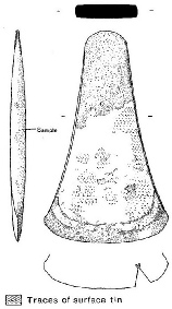
This flat axe was found before 1960 in ploughsoil on or near a barrow in the parish of Barton Stacey, Hampshire. Unfortunately, further contextual information is lacking. It was presented to the British Museum.
It was immediately of interest because it retained patches of bright silvery-grey patina. Subsequent analysis by the British Museum Research Laboratory attributed this to original tin-plating. This is thought to be a unique example of the technique from a European prehistoric context.
The method is not complex and was not beyond the range of knowledge of an early smith. It is possible that this is the invention of an individual metalworker and the technique was not further developed at the time.
Details of all historic sites in Hampshire are available in the Hampshire Environment Records (HER) posted on Hantsweb.
https://maps.hants.gov.uk/historicenvironment/
The section on How to Use the maps is clear and explains how to link, for each site, to a brief description of what archaeology was found and the opportunity to read a more detailed account.